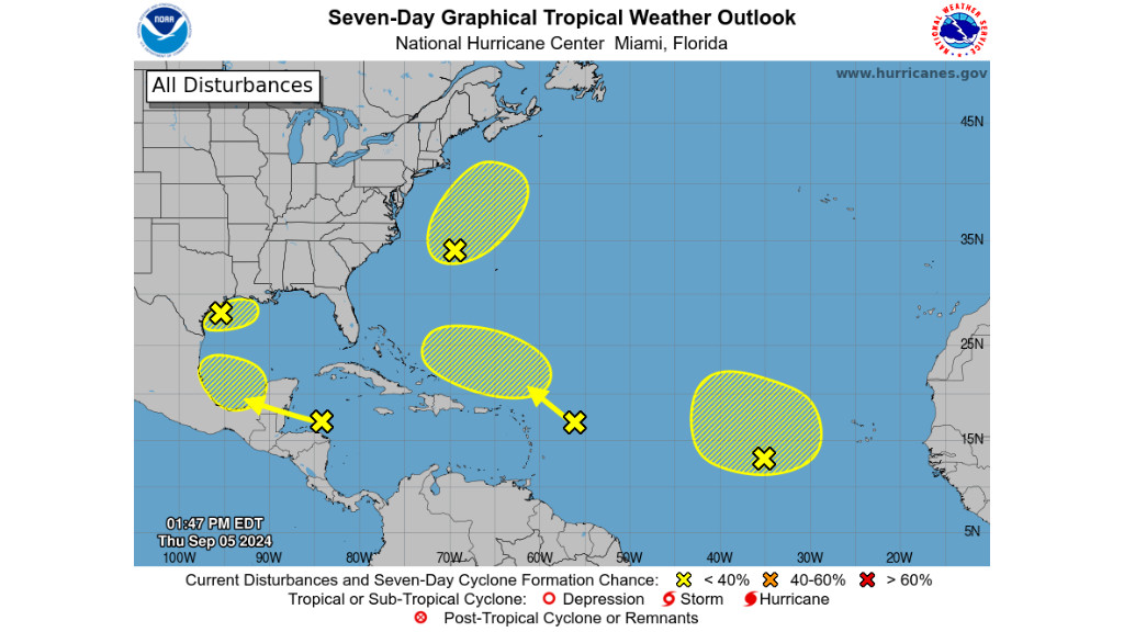
MIAMI-As hurricane season intensifies, the National Hurricane Center (NHC) is closely tracking five tropical disturbances across the Atlantic.
In the Northwest Gulf of Mexico, a broad area of low pressure interacting with a weak frontal boundary is generating showers and thunderstorms.
Despite the current activity, upper-level winds are expected to become less favourable for development by late Friday and Saturday, reducing the likelihood of further growth. Nonetheless, the northern Gulf Coast can expect significant rainfall in the coming days. The chance of formation remains low at 10 per cent through both 48 hours and 7 days.
Further east, a low-pressure system off the coast of North Carolina is showing increased organization, with winds approaching gale force.
While this system could acquire some tropical or subtropical features over the next day or two, it is expected to lose its development potential once it encounters cooler waters by early Saturday. Formation chances for this disturbance are also low, standing at 30 per cent through both 48 hours and 7 days.
In the Eastern Tropical Atlantic, an elongated trough of low pressure is producing minimal shower activity.
The system is unlikely to develop significantly through the weekend, though there is a slight chance for slow development early next week as it begins to move north-westward. Current formation chances are near 0 per cent through 48 hours and 20 per cent through 7 days.
Meanwhile, a tropical wave moving westward through the northwestern Caribbean Sea and southwestern Gulf of Mexico is generating disorganized shower and thunderstorm activity.
Although development is not expected before the system reaches Belize and the Yucatan Peninsula early Friday, some gradual development could occur later in the weekend into early next week as it moves over the southwestern Gulf of Mexico. The chance of formation remains near 0 per cent through 48 hours and 20 per cent through 7 days.
Lastly, a tropical wave located a few hundred miles east of the Leeward Islands is producing limited activity due to strong upper-level winds.
While development is unlikely in the near term, conditions may become more conducive for slow growth by early next week as the system moves into the southwestern Atlantic Ocean. Formation chances are near 0 per cent through 48 hours and 10 per cent through 7 days.


