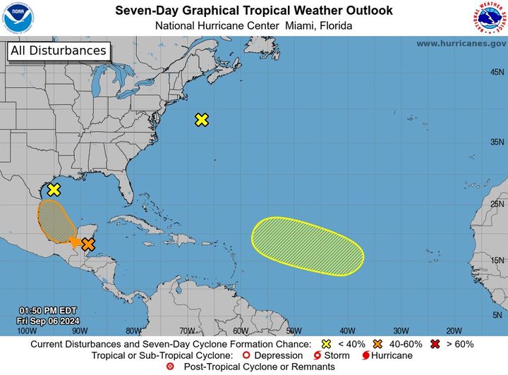
MIAMI (NOAA)-This Friday afternoon, in the Northwestern Gulf of Mexico (AL90), showers and thunderstorms associated with a low pressure system and weak frontal boundary over the northwestern Gulf of Mexico remain disorganized. The low is expected to be absorbed by the front and lose definition by tonight or on Saturday, and therefore tropical cyclone development is not expected. Regardless of development, heavy rainfall is expected to continue and possibly cause flash flooding across portions of the northern Gulf Coast during the next day or so. Additional information on this system can be found in products issued by your local National Weather Service Forecast Office and High Seas Forecasts issued by the National Weather
Service. It has a near-zero chance of formation in the next 48 hours and the next 7 days.
In the Northwestern Atlantic (AL99), an intensifying low pressure system located several hundred miles east of the U.S. Mid-Atlantic coast continues to take on a
non-tropical structure and is now producing winds to storm force. Subtropical development of this system is not expected while it moves north-northeastward at 15 to 20 mph offshore the northeastern United States toward Atlantic Canada. Additional information on this system, including storm warnings, can be found in High Seas Forecasts issued by the National Weather Service. It has a near-zero chance of formation in the next 48 hours and the next 7 days.
In the Southwestern Gulf of Mexico, a tropical wave located over Belize and the Yucatan Peninsula of Mexico is producing disorganized showers and thunderstorms. The wave is forecast to move into the Bay of Campeche on Saturday, where it could then begin to interact with a frontal boundary. A tropical depression could form during the early or middle part of next week while the system moves slowly northwestward over the southwestern Gulf of Mexico. It has a low (20 percent) chance of formation in the next 48 hours and a medium (40 percent) chance in the next 7 days.
In the Eastern and Central Tropical Atlantic, an elongated trough of low pressure over the eastern tropical Atlantic is producing minimal shower and thunderstorm activity.
Development, if any, should be slow to occur while the disturbance meanders through the early part of next week and then begins to move west-northwestward across the central tropical Atlantic during the middle to the latter part of next week.
It has a near zero chance of formation in the next 48 hours and a low (10 percent) chance in the next 7 days.
For the latest forecast, please visit: Hurricanes.gov
For the latest marine forecast, please visit: Hurricanes.gov/marine


